


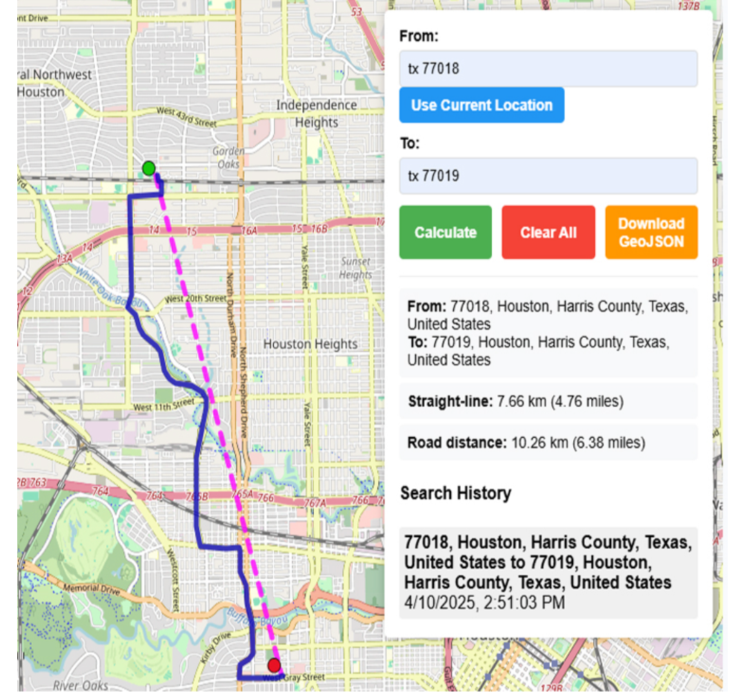
Oasa R1 lawn mower
Alternatives
0 PH launches analyzed!

Oasa R1 lawn mower
The Premier Robotic Reel Mower with Auto-Mapping
49

Problem
Traditional lawn mowing is time-consuming and requires physical effort and precision to handle complex landscapes and lawn edges effectively. Traditional mowers may not navigate complex terrains effectively, leading to uneven grass cutting.
Solution
Oasa R1 is a robotic reel mower equipped with LiDAR vision and automatic 3D mapping that allows it to navigate lawns precisely and trim edges accurately without manual intervention.
Customers
Likely users are homeowners with medium to large-sized lawns, landscaping services, and facilities management companies that maintain lawns in commercial areas. Homeowners and landscaping services are particularly primary customers.
Unique Features
The unique aspects of the Oasa R1 include its LiDAR vision for precise navigation, automatic 3D mapping to handle complex landscaping, and robust edge trimming capabilities which differentiate it from traditional manual mowers.
User Comments
Highly efficient and precise.
Saves time compared to manual mowing.
Handles complex lawn areas well.
Edge trimming is accurate and clean.
Worth the investment for large lawn owners.
Traction
Since its release on Product Hunt, Oasa R1 has received positive reviews, indicating customer satisfaction and effective marketing. Specific metrics like number of users, revenue, and specific version updates were not available.
Market Size
The global robotic lawn mower market is expected to reach $1.4 billion by 2025, growing at a CAGR of 11.2% from 2020 to 2025.
online map maker
freemaptools, gis, web map, mapping, build maps, geodata
3
Problem
Users need multiple specialized tools for different GIS tasks like viewing GPX files, calculating distances, and finding elevation data, leading to time-consuming and inefficient workflows.
Solution
A web-based GIS mapping platform that consolidates tools (e.g., GPX viewer, distance calculator, elevation finder) into one interface, enabling users to access all mapping features in a single platform.
Customers
Urban planners, logistics coordinators, environmental researchers, and field surveyors requiring frequent geodata analysis.
Unique Features
Comprehensive suite of 15+ free GIS tools integrated into one platform, eliminating the need for multiple subscriptions or software installations.
User Comments
Saves time by centralizing tools
Free access lowers entry barriers
User-friendly for non-experts
Useful for logistics route planning
Regularly updated features
Traction
50,000+ monthly active users, 4.7/5 rating on Product Hunt (300+ upvotes), freemium model with premium features generating $20k MRR
Market Size
The global GIS market is projected to reach $25.6 billion by 2030, growing at 12.1% CAGR (Grand View Research, 2023).

Robot Bids
The Marketplace for Robots and Robotics, buy and sell today
3
Problem
Users previously relied on fragmented channels like niche forums, direct manufacturer purchases, or general e-commerce platforms to buy/sell robots and parts, facing limited specialization, inefficient discovery, and lack of centralized trust mechanisms.
Solution
A dedicated robotics marketplace platform where users can list, browse, and transact robots/parts with tailored filters (e.g., industrial vs. hobbyist robots), escrow payments, and community reviews. Example: A manufacturer liquidating 50 warehouse drones via auction-style listings.
Customers
Robotics engineers, industrial automation purchasers, academic researchers, and DIY robotics hobbyists aged 25-50, regularly sourcing/procuring components or systems worth $500-$500k.
Alternatives
View all Robot Bids alternatives →
Unique Features
Vertical-specific search filters (e.g., payload capacity, ROS compatibility), verified seller badges for OEMs/enterprises, and bulk liquidation tools for decommissioned industrial robots.
User Comments
Slashed procurement time by 70% for our factory’s robot arm replacements; Found rare 2012 KUKA controller here; Escrow gave confidence in $28k palletizing bot purchase; Better pricing than Alibaba for sensors; Needs more European suppliers.
Traction
$12k GMV in first 30 days post-launch, 480 registered sellers (35% OEMs), 23 enterprise buyers onboarded via outreach, founder has 2.3k robotics LinkedIn followers.
Market Size
The global industrial robotics market reached $16.78 billion in 2022 (MarketsandMarkets), with 3M+ enterprises needing automation solutions, creating a $2B+ niche secondary market for used/refurbished systems.

Circle Drawing Tool on Map
Radius Map, Draw circle, GIS, Mapping, geoJSON, GIS Map
6
Problem
Users need to draw circles manually with complex GIS tools, leading to inefficiency and lack of precision in radius-based mapping tasks.
Solution
A web-based mapping tool that lets users draw radius circles on a map by entering a radius and clicking a point, instantly visualizing service areas, delivery zones, or geographic boundaries.
Customers
Logistics planners, real estate agents, delivery service managers, and urban planners requiring quick radius visualization for spatial analysis.
Unique Features
Simplified, no-code interface for instant circle generation on maps; exports geoJSON data; free and accessible without GIS expertise.
User Comments
Saves time compared to traditional GIS software
Intuitive for non-technical users
Helpful for defining service areas
Free alternative to paid tools
Lacks advanced customization but meets basic needs
Traction
Launched as a free web tool with 10k+ monthly active users; integrated into workflows of logistics and real estate companies.
Market Size
The global GIS market is projected to reach $10.5 billion by 2025, driven by demand for spatial analysis in logistics and urban planning (MarketsandMarkets).
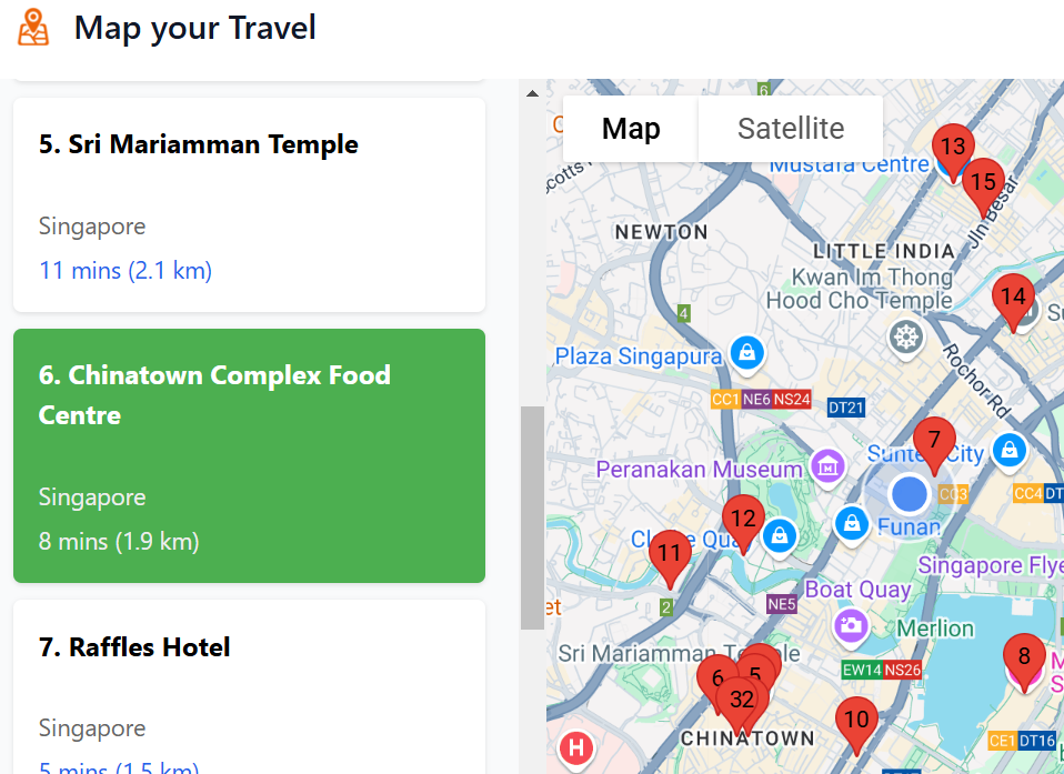
Map Your Travel
Map travel places on any webpage onto Google Maps
5
Problem
When readers look up food blogs or travel forums, they traditionally have to manually search each mentioned location on Google Maps, which is time-consuming and inefficient.
manually search each mentioned location on Google Maps
Solution
This is a browser extension that can identify and map every mentioned location, such as restaurants, onto Google Maps.
identify and map every mentioned location
Customers
Travel bloggers, food enthusiasts, and frequent travelers looking for a more efficient way to plan and execute their travel itineraries.
They are typically between the ages of 25-45 and frequently use online resources to plan trips and dining experiences.
Alternatives
View all Map Your Travel alternatives →
Unique Features
The extension instantly maps numerous locations from any webpage onto Google Maps, saving users time.
Includes travel times and distances between multiple points, enhancing route planning.
User Comments
Users appreciate the ease of use and time saved.
Some mention it enhances their travel planning experience.
A few comments suggest minor improvements for better user experience.
Users find it particularly useful for large cities with numerous dining options.
A small fraction of users mentioned occasional bugs.
Traction
Newly launched.
Featured on ProductHunt with increasing interest.
Market Size
The global travel technology market was valued at approximately $13.6 billion in 2022, with a continued growth trend as digital solutions for travel planning become more sought after.

Styled Map
Google maps style designer & static map image exporter
8
Problem
Architects and designers need presentation-ready Google Maps styles for their projects but struggle with manual customization and complex API setups which are time-consuming and require technical expertise.
Solution
A design tool that allows users to customize Google Maps styles with live previews and export high-resolution static map images without API integration, offering curated themes and instant export capabilities.
Customers
Architects, designers, and urban planners who require visually polished maps for client presentations or project documentation.
Alternatives
View all Styled Map alternatives →
Unique Features
Curated map themes, no-code styling interface, live preview, and direct export of print-ready static map images.
User Comments
Simplifies map customization for non-developers
Saves hours on client presentations
High-resolution exports enhance project visuals
Intuitive interface compared to API tools
No coding required for professional results
Traction
Launched on Product Hunt with 500+ upvotes
Used by 10k+ professionals across architecture and design firms
Featured in design and tech publications
Market Size
The global architecture and design services market is valued at $450 billion (2023), with increasing demand for digital visualization tools.

Street View Live Satellite Map
Explore world with satellite map, get route planner with map
4
Problem
Users rely on traditional maps for navigation, lacking real-time visuals and interactive features.
Solution
Mobile application offering live street view satellite maps and instant GPS navigation with advanced 3D features.
Provides real-time 3D street map views, full-screen street map zooming, and instant GPS navigation.
Customers
Travelers who need precise navigation and real-time views for exploring unfamiliar areas.
Unique Features
Real-time 3D street map views
Full-screen street map zooming
Instant GPS navigation
User Comments
Easy to use and provides accurate navigation
Great visuals and interactive features
Helpful for planning routes and exploring new places
Enhances the travel experience
Improves safety and efficiency in navigation
Traction
Over 100k downloads on Google Play Store
Positive user ratings averaging 4.5 stars
Market Size
Global navigation app market size was valued at $39.7 billion in 2021

Pave Robotics
Robots that repair roads
177
Problem
Paving companies and local governments often face issues with maintaining and repairing road surfaces. The current situation involves manual work by human laborers which is time-consuming, costly, and prone to lower-quality results. The **drawbacks of this old situation** include high labor costs and risk of human error in sealing cracks in asphalt efficiently.
Solution
Pave Robotics offers a **robotic solution** that automates the task of sealing cracks in asphalt. Users can employ these robots to work continuously around the clock, improving efficiency and quality over traditional methods. The robots are capable of delivering higher-quality results than human workers, reducing time and cost for paving companies and local administrations.
Customers
**Paving companies** and **local governments** who are involved in the maintenance of road infrastructure and are looking to save time and money in road repair operations through advanced automated solutions.
Alternatives
View all Pave Robotics alternatives →
Unique Features
The robotic solution offers automated 24/7 operations for crack sealing in asphalt, promising better quality than human labor, which is unique compared to traditional methods that rely heavily on manual labor.
User Comments
Users appreciate the cost savings provided by the robot.
Continuous 24/7 operation is seen as a major benefit.
Many users find the increased quality of repairs impressive.
There are comments on its ability to reduce the workload of human workers.
Some users express an interest in scalability and future capabilities.
Traction
Pave Robotics is a newly launched product that has gained attention in technological and governmental sectors. Specific metrics such as the number of robots deployed, specific operational savings, or revenue figures are not publicly available yet.
Market Size
The global road building and maintenance market, encompassing paving automation solutions, was valued at approximately **$92 billion** in recent years, indicating a significant potential market for robotic and automated solutions like Pave Robotics.

Robots Wiki
Discover robots
1
Problem
Users need to research robots and automation across multiple fragmented sources, leading to time-consuming and inefficient discovery of comprehensive, up-to-date information.
Solution
A centralized wiki platform where users can explore AI-powered robots, humanoids, and automation trends with curated technical specs, industry insights, and future projections (e.g., browsing Boston Dynamics’ Atlas or Tesla Optimus details).
Customers
Robotics engineers, AI researchers, tech investors, and automation industry professionals seeking consolidated technical and market data.
Alternatives
View all Robots Wiki alternatives →
Unique Features
Aggregates robot specifications, manufacturer details, use cases, and industry impact analysis in one AI-enhanced knowledge base.
User Comments
Saves hours compared to Googling
Reliable specs for academic projects
Useful for competitor analysis
Regularly updated with new models
Clear categorization by robot type
Traction
Launched on ProductHunt in 2024, featured in top AI/robotics newsletters with 1K+ active users monthly (exact revenue/Numbers unspecified).
Market Size
The global industrial robotics market alone reached $72.17 billion in 2023, projected to grow at 15.2% CAGR through 2032 (Precedence Research).

Problem
Users manage frequently used web URLs through traditional bookmarks or manual entry, leading to cluttered bookmark bars and time-consuming manual URL typing.
Solution
A Chrome extension enabling users to create aliases for URLs and auto-complete omni-box navigation, e.g., typing 'gh' to access GitHub instantly.
Customers
Professionals, researchers, and developers who frequently navigate between web tools, plus students and casual users seeking streamlined browsing.
Unique Features
On-device link storage (no cloud dependency), lightweight design, and seamless browser-integrated auto-complete for URLs.
User Comments
Saves time by reducing repetitive typing
Eliminates bookmark clutter
Simple setup with no learning curve
Privacy-focused (data stays local)
Enhances daily browsing efficiency
Traction
Newly launched on Product Hunt (exact metrics unspecified)
Market Size
The global productivity software market was valued at $96.36 billion in 2022 (Grand View Research).